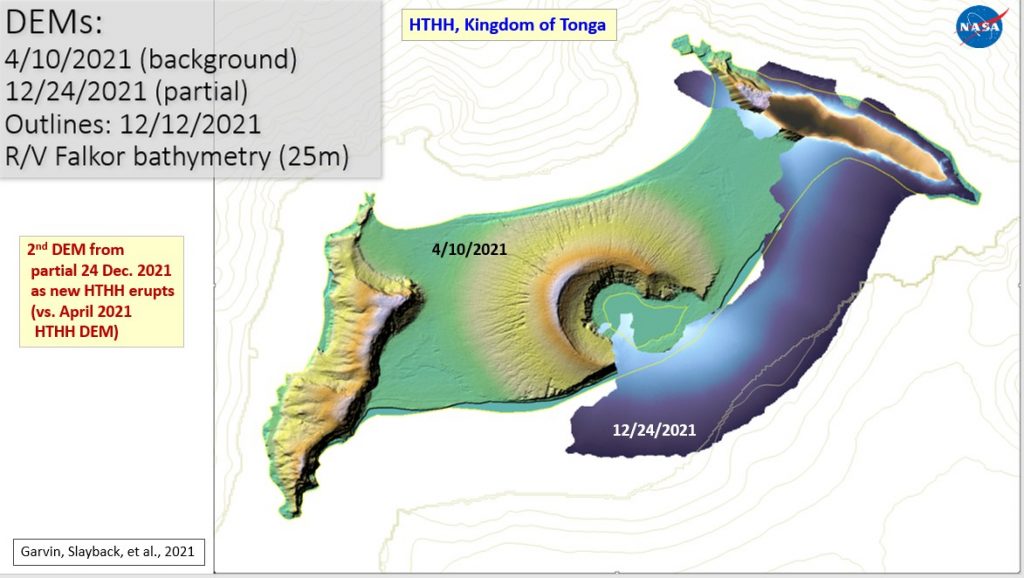
A digitised map released by Tonga Geological Services yesterday shows Tonga has acquired some new territory.

The image appeared to show the volcanic activity occurred 65km north of Tonga’s main island Tongatapu has formed a 600m extension east of Hunga Tonga Hunga Ha’apai on December 25, 2021, the Services said.
The digitised map was designed based on NASA’s satellite images, it said.
The release of the image came after some spectacular footages recorded from a boat close to the scene by some eyewitnesses. The footages, which were taken by Ioana Sugar Kalo and Bronco Sugarelli on December 28 showed explosive eruption of the volcano continues characterised by what appeared to be dark and dense mixtures of hot volcanic fragments, ash and gas.
NASA described Hunga Tonga Hunga Ha’apai, which are 1.6km apart, as two islands sitting atop a large seamount.
“These volcanic islands stand just 128 and 149 meters (420 and 490 feet) above sea level”, NASA reported in 2014.
Hunga Tonga Hunga Ha’apai, which stands for its locations between Tongatapu and Ha’apai islands, was separated from the sea by a shallow sandbar, forming a lagoon.
“Initially it was believed that the entire island would be eroded rapidly, but scientists now believe that the process may take decades”.
Since the current volcanic activity last month, the Ha’apai residents have been issued with warnings that acid rain from the eruption threatened water tanks and they should remove guttering systems from rainwater tank storage until the eruption finishes. These should not be reinstalled until after the next rainfall, to reduce the risk of contamination.


