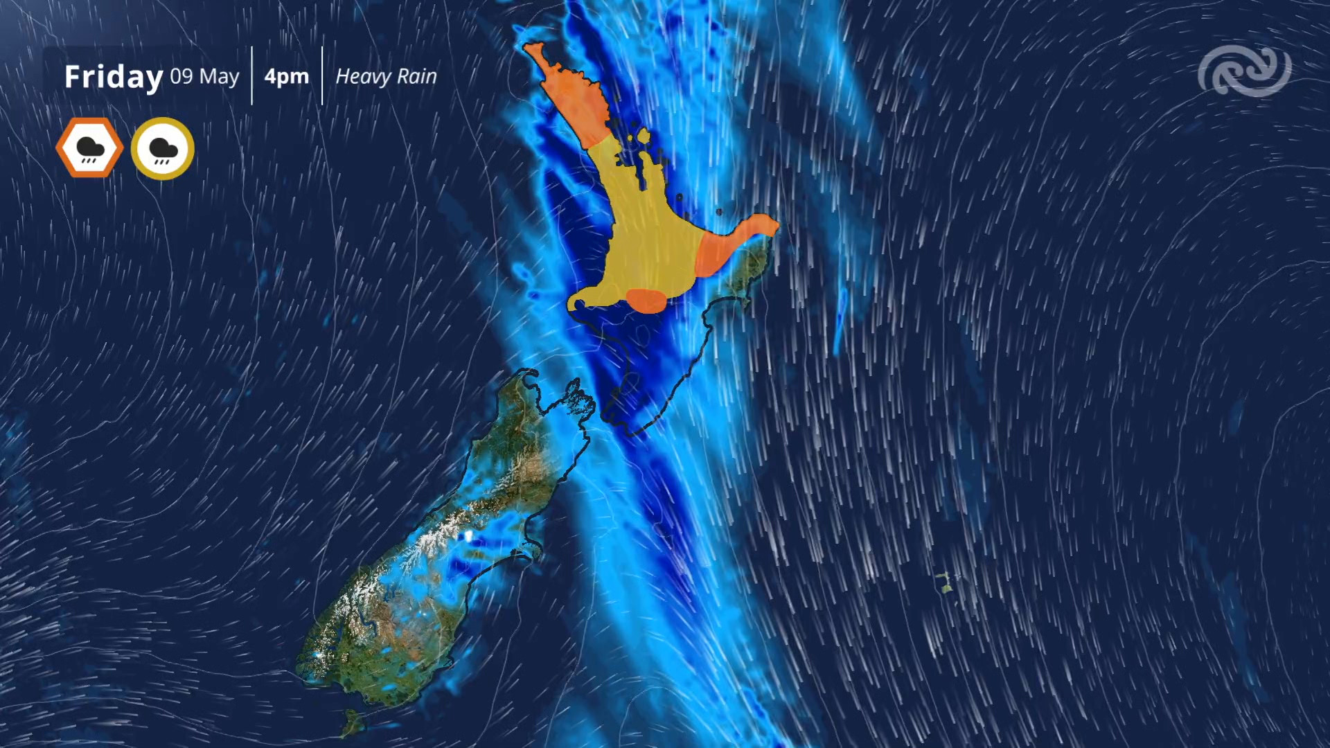
Severe thunderstorm watches are in place for the upper North Island with downpours and flash flooding possible throughout the day.
1News weather presenter Dan Corbett warned conditions in the mid-afternoon were likely to provide a “sucker’s gap” where a lull in the rain might deceive people into believing the worst of the weather had passed.
He said there would be more heavy rain to come around the afternoon commute time and Auckland workers making their way home should be prepared.
Within the hour to 5.30pm, 23mm of rain had fallen on the North Shore suburb of Birkdale and 22mm of rain had dropped at Kumeū, in the west of Auckland.
Added to the frustration for commuters, a vehicle broke down on the westbound Upper Harbour Bridge, with NZTA warning there would be added delays for motorists.
Dozens of domestic flights were also delayed as a result of the weather. According to the Auckland Airport website, dozens of arrival and departure flights were pushed back.
Heavy rain warnings and strong wind watches were also issued for other regions.
This morning, MetService issued a severe thunderstorm watch for Auckland, Great Barrier Island, the Coromandel Peninsula the Bay of Plenty, and Rotorua alongside existing alerts for Northland and Taranaki.
“There is a moderate risk of localised downpours of 25 to 40 mm/h,” the forecaster said.
“Rainfall of this intensity can cause surface and flash flooding, especially about low-lying areas such as streams, rivers or narrow valleys, and may also lead to slips.”
Yesterday, MetService warned of an active front, preceded by gale north-easterlies, that was expected to move over the upper North Island today.
Orange heavy rain warnings were issued for Northland, the Bay of Plenty, Tongariro National Park, and Mount Taranaki.
MetService meteorologist Heather Keats told Breakfast that for many parts of the country overnight it was “very windy and quite wet”.
“There’s an active front that is moving up and over the South Island, that’s been responsible for all the warnings and watches for rain and strong winds as well.”
She said the strongest wind gust recorded was 150km/h in Methven high country.

“As for the rain, Tasman District has received the most in the last sort of 6 to 12 hours, but actually Hokitika in the last hour had 23mm of rain,” she said.
Keats said as that front moves north, the South Island would get “a much brighter and calmer afternoon and evening”.
However, in the North Island, Keats said another area of low pressure was going to hit Northland and Auckland today.
“There’s a whole lot of rain, a whole lot of wind still to come.”
Watch 1News weather presenter Daniel Corbett’s full breakdown of the storm on TVNZ+
She said the rain in Northland was just starting to arrive as of 7am, and heavy falls for Auckland were expected today into the afternoon and evening.
“We’re going to have some downpours and its likely to be thunderstorms as well today.”
Localised downpours could spark up during the middle of the day in Auckland.
Full list of weather watches and warning

Severe thunderstorm watch
Northland – 8 hours from 9am to 5pm
Taranaki – 7 hours and 30 minutes from 8.30am to 4pm
Auckland, Great Barrier Island – 5 hours from 2pm to 7pm
Coromandel Peninsula – 6 hours from 4pm to 10pm
Bay of Plenty, Rotorua – 6 hours from 5pm to 11pm
Orange heavy rain warning
Northland – 9 hours from 9am to 6pm
Bay of Plenty east of Maketu, and Gisborne/Tairawhiti north of Ruatoria – 21 hours from 9am Friday to 6am Saturday
Mount Taranaki – 6 hours from 9am to 3pm
Tongariro National Park – 11 hours from 9am to 8pm
Heavy rain watch
Auckland including Great Barrier Island – 11 hours from 9am to 8pm
Coromandel Peninsula, and Bay of Plenty west of Maketu, except Rotorua, including the Kaimai Range – 13 hours from 9am to 10pm
Waikato excluding the Kaimai Range, also Waitomo, Taumarunui and Taupō – 11 hours from 9am to 8pm
North Taranaki excluding Mount Taranaki – 9 hours from 9am to 6pm
Nelson northwest of Motueka – 3 hours from 9am to 12pm
Wellington and Kapiti Coast – 5 hours from 12pm to 5pm
The Richmond and Bryant Ranges, Rai Valley – 6 hours from 9am to 3pm
Auckland including Great Barrier Island – 8 hours from 9am to 4pm
South Taranaki, inland Whanganui and Taihape – 6 hours from 9am to 3pm


