Nukuʻalofa, Tonga — A tropical cyclone warning is now in force for Tongatapu, ʻEua, Tele‑ki‑Tonga and Tele‑ki‑Tokelau as Severe Tropical Cyclone Vaianu, a Category 3 system, continues to affect parts of the kingdom with strong winds, heavy rain and dangerous seas.
The warning was issued by the Fuaʻamotu Tropical Cyclone Warning Centre at 7am on Wednesday, 8 April 2026, under Tropical Cyclone Advisory Number 04.
Authorities have placed strong wind warnings, heavy rain warnings and flash flood advisories over Tongatapu and ʻEua, while coastal warnings have been intensified across several island groups.
For coastal waters, the gale warning for Tele‑ki‑Tonga and Tele‑ki‑Tokelau has been upgraded to a storm warning, with heavy damaging north‑westerly swells expected to persist. Strong wind warnings over Tongatapu and ʻEua coastal waters have also been upgraded to gale warnings.
A strong wind warning and small craft advisory are now in force for Haʻapai coastal waters, while small craft advisories remain active for Tongatapu, ʻEua, Tele‑ki‑Tonga and Tele‑ki‑Tokelau.
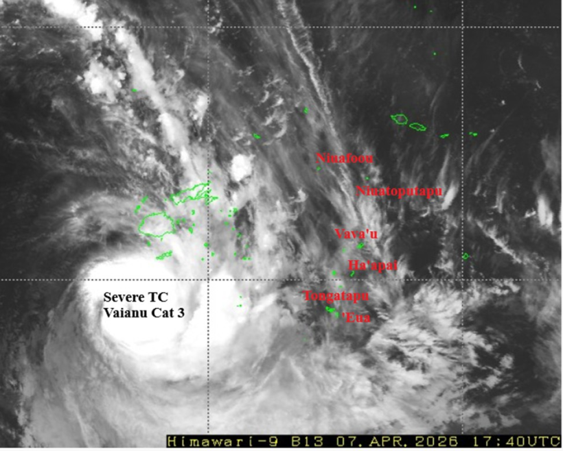
Cyclone Location and Movement
As of 5am this morning, Cyclone Vaianu was located near latitude 20.7° South and longitude 176.3° East, approximately 880 kilometres west of Nukuʻalofa and 905 kilometres west of ʻEua. The system was also about 365 kilometres southwest of Suva, Fiji.
The cyclone is tracking south to southeast at around 12 knots (24 km/h). Maximum sustained winds near the centre are estimated at 85 knots (170 km/h), with gusts reaching 110–120 knots (220–240 km/h).
On its current track, the cyclone is forecast to lie about 795 kilometres west of Nukuʻalofa by 1:00pm today, with its associated cloud bands, heavy rain and storm‑force winds expected to affect Tele‑ki‑Tonga, Tele‑ki‑Tokelau and parts of Tonga.
Area Forecasts
Tele‑ki‑Tonga and Tele‑ki‑Tokelau are expected to experience north to northeast winds of 35–45 knots (70–90 km/h), with gusts up to 55–65 knots (110–130 km/h). Conditions will be mostly cloudy to overcast with heavy rain, isolated thunderstorms, poor visibility, and very high seas of 6–9 metres, along with damaging north‑westerly swells of up to 4–6 metres.
For Tongatapu and ʻEua, northeast winds of 15–20 knots (30–40 km/h) are expected to increase to 30–40 knots (60–80 km/h) at times tonight, particularly in western and southern waters. Cloudy conditions with occasional heavy showers and possible thunderstorms are forecast, with rough seas up to 3–4 metres.
In the Niuas, Vavaʻu and Haʻapai, northeast winds of 10–20 knots (20–40 km/h) are forecast, rising to 25–30 knots at times tonight over Haʻapai coastal waters. Seas are expected to be moderate, becoming rough over Haʻapai waters later tonight.
High tide is expected at 11.40am, with low tide at 6.15pm, raising concerns about coastal flooding in exposed areas.
At 7am, the mean sea level pressure recorded at Fuaʻamotu Airport was 1010.4 millibars, with relative humidity at 90 percent.
The Meteorological Service has advised the public, especially coastal and low‑lying communities, mariners and small craft operators, to take precautionary measures and closely monitor updates.
The next tropical cyclone advisory for Cyclone Vaianu will be issued at 1pm today.


