By rnz.co.nz and is republished with permission
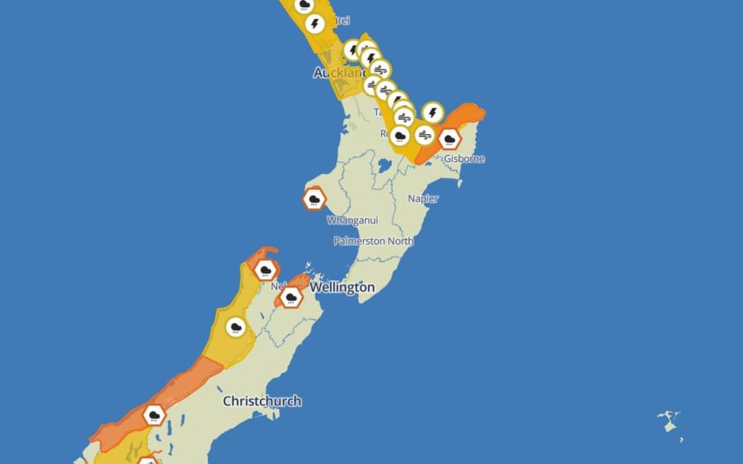
Weather warnings around the North Island’s East Coast have ratcheted with intense downpours forecast to hit Tai Rāwhiti.
There are numerous heavy rain warnings and watches in place across the country. Photo: Supplied / MetService
Severe thunderstorm watches are also in place for parts of the upper North Island.
Gisborne and the region north of Ruatoria was under a heavy rain watch on Wednesday, which has now been upgraded to an orange warning.
Up to 100mm of rain was expected to fall about the ranges, with lesser amounts closer to the coast.
The warning will remain in place from midnight until 6pm Thursday.
There was also a yellow strong wind watch north of Ruatoria and a yellow severe thunderstorm watch for Gisborne.
MetService warned streams and rivers may rise rapidly, along with surface flooding, slips and hazardous driving conditions.
There was also a heavy rain warning in Taranaki, with up to 140mm of rain expected to fall.
“Almost all parts of the country can expect wet weather by the end of Friday, with heavy rain for some,” MetService said earlier.
Starting in Northland, there was a heavy rain watch in place from 10am until 1pm on Wednesday, with a moderate chance of being upgraded into a warning.
Severe thunderstorm watches have been issued for Northland, Auckland, Great Barrier Island from 8pm on Wednesday.
MetService said: “A series of active fronts preceded by a strong and moist northeast flow move onto northern parts of the North Island from this afternoon, reaching Auckland tonight. About Northland and Auckland (including Great Barrier Island), there is a moderate risk of some thunderstorms being severe between 8pm Wednesday and 5am Thursday, producing localised downpours of 25 to 40 mm/h. This risk should ease in Northland around 2am.
“Note, these downpours could occur with or without thunderstorms. Rainfall of this intensity can cause surface and/or flash flooding, especially about low-lying areas such as streams, rivers or narrow valleys, and may also lead to slips. Driving conditions will also be hazardous with surface flooding and poor visibility in heavy rain. Some of these thunderstorms may also be squally, and produce strong wind gusts of 80 to 100 km/h or possiblly stronger. Wind gusts of this strength can cause some damage, including trees and power lines, and may make driving hazardous.”
There is also a thunderstorm watch for Coromandel Peninsula, Bay of Plenty, Rotorua, Gisborne from 1am Thursday.
The Coromandel also has a heavy rain watch kicking in from 7pm Wednesday until early Thursday morning.
“Rainfall amounts may approach warning criteria, especially about the ranges.”
The Western Bay of Plenty should expect “periods of heavy rain” and “localised downpours” from 9pm through to the morning, with a high chance of levels reaching warning criteria.
MetService advised locals to clear gutters, avoid low-lying areas and drive cautiously.
“The school holidays started out nice and bright, but things do take a turn today and into Thursday,” MetService meteorologist Mathapelo Makabulane told Morning Report on Wednesday.
“For the North Island, we’re also expecting things to get progressively wetter, especially in the northern half of the North Island and then eventually quite wet conditions for places like Northland, Coromandel and the Bay of Plenty into Thursday.”
Heavy rain and snow expected for parts of the country
In the south, heavy rain warnings were in place for Tasman, northwest of Motueka – with up to 160mm expected – and the Richmond and Bryant Ranges, including the Rai Valley, where 110m might fall. Both areas could have their orange warnings upgraded to red.
“So today we’re expecting – especially for the South Island – some wet weather to start coming on, especially in those western parts,” Makabulane said. “But that does spread across the island even reaching the eastern parts, places like Canterbury, Otago later on this evening and into tomorrow….
“The heaviest rain is expected in the mountainous areas, but places away from the ranges can also expect quite wet weather.”
A heavy rain watch was in place for the Buller and Grey districts, with downpours particularly expected about the Paparoa Ranges.
Westland looks set for the heaviest rain nationwide, with up to 200mm expected about the ranges, and a bit less closer the coast.
“Peak rates of 15 to 20mm/h expected about the ranges from late Wednesday morning to early Wednesday evening.”
Central Otago and Queenstown Lakes could expect heavy snow above 700m.
“It seems like we’ve had quite a few snowfall events lately and yes, the latest one is expected for the inland part of Otago – so that includes the Southland, the Queenstown Lakes District as well, and we’re looking at that from this afternoon onwards into the evening as well,” Makabulane said.
North Otago, Dunedin and Clutha residents should expect heavy rain possibly exceeding warning criteria for a whopping 33 hours from 3am Thursday, with a high chance the situation will be upgraded to warning level.
And finally, the northern half of Southland should expect periods of heavy rain from 9am Thursday, with a chance it will last into the night and possibly upgraded to a warning.
“Once this band of rain moves through, the good news for the North Island is that things look like they clear up pretty quickly… All in all it looks like Friday, we could see some bright spots for most of the country,” Makabulane said.
‘Drive to the conditions’
Waka Kotahi / NZ Transport Agency Waka Kotahi warned school holiday travellers to take care, saying some might not expect snow on the roads this late in the year.
“We always do get a few short, sharp blasts,” said journey manager Tresca Forrester.
“Everything sort of happens today into the early hours of tomorrow. So if you are travelling, it would pay to just check probably two things: the MetService has really great forecasting and warnings in place… and also our journey planner,which is obviously the source of truth for 24/7 for our road closures, et cetera.
“At the moment every road is open except for the Milford Road [SH94], so that’s down to the Milford Sound there, and that is closed due to snow at the moment.”
Waka Kotahi warns drivers to take care amid heavy rain
It also remained “avalanche season” in that area, Forrester said.
“That actually is why the road is closed here this morning, and they’re expecting an update around sort of midday.”
In areas where rain was expected, she said to be aware of “small slips, rocks, things like that”.
“Drive to the conditions. – so if it is streaming down with rain, it’s just what you’re feeling comfortable and safe with, and just take it easy, you know? Take your time. You might have a car full of kids, but you know just stop into those awesome local cafes along the way and get a cuppa.”


