The last fragments of land created by the devastating 2022 Hunga Tonga–Hunga Ha‘apai eruption are continuing to erode, according to new aerial observations released by Tonga’s Ministry of Lands, Survey, Planning and Natural Resources.
The deadly eruption and tsunami resulted in three confirmed deaths in Tonga, according to official reporting by the Tongan government and the United Nations at the time.
The victims included British national Angela Glover, a 65‑year‑old woman from Mango Island, and a 49‑year‑old man from Nomuka Island.
The tsunami’s impact was also felt internationally, with high waves causing two deaths in Peru, bringing the total number of fatalities linked to the disaster to at least five.
The latest finding emerged during a United States–supported reconnaissance flight conducted on 17 February 2026.
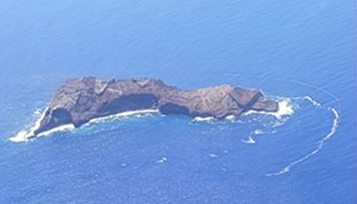
The Ministry confirmed that during the survey, the remaining section of Hunga Tonga–Hunga Ha‘apai showed no visible signs of volcanic activity, but the landmass continues to shrink as the sea steadily reclaims what is left of the once‑significant island formed in the years before the 2022 explosion.
The update was issued in a public notice following an invitation from the United States Embassy in Fiji, which arranged for the Prime Minister of Tonga, Lord Fakafanua, MEIDECC CEO Mr Sione Akau‘ola, and Deputy CEO for Natural Resources Division, Mr Rennie Vaiomounga, to board a demonstration flight of a U.S. Government Pacific regional jet.
The flight doubled as an opportunity to assess multiple active volcanic sites across Tonga.
Aerial checks confirmed that no steam, ash, discoloured water, or other indicators of unrest were visible at Hunga Tonga–Hunga Ha‘apai. The Ministry reported that only the eroding remnant of the island formed prior to the 2022 eruption remains, highlighting how dramatically the landscape has changed since the explosion that triggered a Pacific‑wide tsunami.
Images released with the notice show the reduced landmass from both distance and close‑range perspectives.
The survey team also inspected Tofua Volcano, where gas emissions confirm the volcano remains active but stable. Low to moderate steam and gas emissions were observed at the Lo‘uta crater, with plumes rising to moderate heights.
The Ministry reported no ash emissions or volcanic explosions during the flight.
The mission included an assessment of Home Reef, one of Tonga’s most active submarine volcanoes in recent years. While the notice did not include detailed observations in the visible section, the Ministry confirmed the site was part of the aerial survey.
The U.S. regional jet, originally intended for Pacific Heads of Government travel, allowed Tongan officials an opportunity to view remote volcanic areas from the air—an important component of hazard monitoring in a nation vulnerable to rapidly changing geological conditions.
The Ministry said such cooperation strengthens Tonga’s ability to track volcanic unrest and respond effectively to emerging risks.


