By RNZ.co.nz and is republished with permission
Severe gales have caused flight cancellations, road closures and power outages throughout much of the country on Sunday and into Monday morning.
Much of the South Island, and the lower North Island were put under strong wind warnings or alerts.
The storm has forced ferry sailings to be cancelled and strong winds in Wellington prevented planes from being able to land at the airport from about 5.30pm on Sunday, causing a number of cancellations and delays.
MetService data showed a gust of 246.3kmh recorded just before 9pm on Sunday at Cape Turnagain, south of Pōrangahau on the east of the North Island, where sustained winds of 192.6kmh were measured.
In Wellington, winds gusted up to 130-140kph and at the Remutaka Hill gusts were measured at 185kph.
Emergency services had multiple call-outs today related to trees and vehicles being knocked over due to the wind, with fire station alarms sounding repeatedly through the afternoon and evening in some areas.
MetService warned people to stay up to date with the forecast (MetService warnings can be found here).
Air New Zealand has cancelled all flights into Wellington for the rest of Sunday, according to their website.
In the North Island, Wellington, the Tararua District, and parts of Wairarapa and Hawke’s Bay are under an orange wind warning until Monday morning.
In the South Island, an orange wind warning is in place for Marlborough until 10pm, and the Marlborough Sounds, Clutha, Southland, Stewart Island, and Fiordland south of Milford Sound, until Monday.
State Highway 2 is closed over the Remutaka Hill between Featherston and Kaitoke due to strong winds, Waka Kotahi said.
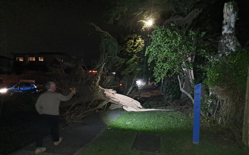
A large macrocarpa tree came down onto Manly Street in Paraparaumu Beach during the storm. Photo: RNZ/ Michael Cropp
Aratere Interislander ferry sailings for Sunday were cancelled due to the rough conditions.
But Bluebridge Ferries sailings in the early hours of Monday morning were scheduled to go ahead after earlier weather-related cancellations, but it warned they would be rough and may take longer.
In Mt Cook National Park at Mueller Hut, a gust of 199 kmh was reported, the strongest in three years, NIWA said.
There had also been reports of vehicles affected by strong winds.
Police responded to reports of a crash on Mount Cook Road, where a campervan rolled over into a ditch about 1:50pm and another crash where a caravan went down a bank on the Tekapo-Twizel Road about 1:45pm. There were no reported major injuries.
Severe gales in Wellington were preventing planes from landing at the airport.
Aircraft had not been able to land since about 5.30pm on Sunday, due to the strong wind, a Wellington Airport spokesperson said.
They said passengers should check the status of their flights with their airline.
A number of flights in and out of Wellington had been delayed or cancelled.
Christchurch was under a strong wind watch until 8pm Sunday.
And a number of flights into Christchurch were also listed as delayed or cancelled on Christchurch Airport’s website.
Power outages
The strong winds knocked out the power supply to many households across a handful of regions as strong winds pummelled parts of the country.
In Wellington, power was cut to thousands of properties on Sunday, Wellington Electricity said.
By 10pm on Sunday, the largest of those faults had been fixed, with power back for about 6000 properties in the Hutt Valley, leaving about 1000 properties still blacked out late into the night.
But by 11pm, the number without power was back up to 3000 properties.
Powerco said the areas most affected included New Plymouth, Wairarapa and Mt Maunganui.
By 10pm Sunday their outage map showed just over 3800 outages, but by 11pm the number in the dark had dipped below 3000.
Storm disrupts ferries and roads, strong winds expected into Monday
Interislander operations general manager Duncan Roy said Kaiarahi had stayed put at Cook Strait, rather than anchor in Wellington harbour overnight from Saturday night into Sunday, due to the high winds in the area.
Since then, the Kaiarahi had returned, and the Kaitaki ferry, which was in Wellington, departed at 8.45am on Sunday.
MetService also had a heavy swell warning for Kāpiti-Porirua Coast – Otaki to Cape Terawhiti.
Police warned drivers travelling on motorbikes or in vehicles with a high point of gravity to take care with the strong winds, in particular for Manawatū, Whanganui-Ruapehu, and Taranaki roads.
“Drive to the conditions, and stop and wait if you feel unsafe.”
People reported trees down across SH1 at Himatangi, north of Foxton, on Manly Street in Paraparaumu Beach and across the entrance to Wellington’s Northland Tunnel, in Raroa Road. And election hoardings were reportedly being ripped up by the wind and thrown about in many places.
Wind gusts of up to 130kph had been expected for Wellington, and by Sunday evening, MetService meteorologist Alec Holden said they were being recorded at 130-140kph.
“Having walked in it myself, I can confirm that I’ve had a few of those typical Wellington pauses as the winds pick up.”
Forecasters did not expect much of the wind to die down until at least the early hours of Monday morning, and a cold front was moving slowly across the country, Holden said.
Heavy rain warnings were in place on Sunday for Canterbury, Westland, and Fiordland, with heavy rain watches issued for much of Otago.
“A series of fast moving fronts affects much of the country during the outlook period, bringing rain to western parts of central and southern New Zealand and west to northwest gales to many places – severe weather warnings and watches are in force for a number of regions,” MetService said.
Fire in Canterbury
Earlier, strong winds were hampering efforts to put out a vegetation fire in Culverden, North Canterbury.
Fire and Emergency was called to the scene at Pahau Downs just 5am on Sunday.
The blaze was about 150 metres long in a gully and took out an old shed, but was contained.
Hurunui Mayor Marie Black said crews were working hard.
“We are still experiencing high winds, however we have had a little bit of … nor’west rain which may well be easing the situation, but it’s been fairly intense thought the night.”
Crews from surrounding areas, including Hurunui, also arrived to help. It was not known how the fire started.
Meanwhile, Fire and Emergency warned people to be vigilant when doing burn offs in paddocks and vegetation given the high winds.
On Thursday, a helicopter was needed to fight a burn that got out of control near Cheviot in Canterbury, and in Clutha in Otago, a vegetation fire was started when a burn-off reignited.
A restricted fire season had already been declared for the Upper Waitaki and Central fire zones of Otago.
Fire permits had been suspended in those areas until Monday, because of the current very high fire danger.


