Cyclone Ian was upgraded this morning at 2:15am to Category 5 meaning it could hit with the strongest wind gust at more than 280km/h which it will be extremely dangerous and causing widespread destruction.
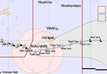
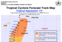
Severe tropical Cyclone Ian is heading towards Vava'u after it was located near 18 decimal 2 south 174 decimal 9 west or about 100km northwest of Hunga (vv) and 105km northwest of Longomapu (vv) or about 185km north-northwest of Lifuka at 1:00am, Tonga Met Services says.
Tropical cyclone Ian has estimated winds of 110knots near its centre with momentary gusts up to 130knots.
The cyclone is moving southeast at 5knots. On this track severe tropical Cyclone Ian is expected to lie about 50km west of Vava'u (near late) at around 7am tomorrow.
On its current track, Tropical Cyclone Ian may bring:
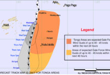
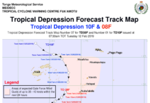
Damaging gale force winds to Vava'u with in the next 3hrs, destructive storm force winds in the next 3-6hrs and very destructive hurricane force winds in the next 6-12hrs
For the Ha'apai group tropical cyclone Ian may bring damaging gale force winds in the next 6hrs, destructive storm force winds in the next 6-12hr and very destructive hurricane force winds in the next 12-18hr.
For Tongatapu and 'Eua the cyclone may bring damaging gale force winds in the next 12-18hrs
A hurricane warning remains in force for the Vavau and Haapai groups.
A gale warning remains in force for Tongatapu,'Eua and nearby islands.
A strong wind warning remains inforce for Niuafo'ou, Niuatoputapu and Tafahi.
A damaging heavy swell advisory remains inforce for coastal waters of Vava'u and Ha'apai group.
A heavy rain advisory remains in force for the vava'u and ha'apai groups.


